    |
Grade 4 Science
Unit 6 |
 |
Weather or
Not, Here it Comes!
Essential Question:
How can we analyze the weather patterns to predict future
forecasts? |
| |
Enduring Understandings:
*Weather data helps predict future forecasts.
*Forecasting the weather helps in daily and long-range planning. |
Student Resources |
Big Idea:
We can use weather patterns to predict future forecasts.
Describe different seasonal weather conditions by using data collected
from weather instruments, models, or drawings. (2.E.2.a)
|
   The
National Weather Service Forecast Office
(revised link) The
National Weather Service Forecast Office
(revised link)
Once at the site, click on
Baltimore to get data about the city and a
close-up map of the region. Go back to the original map and click on
Cumberland for information about a mountainous region. At the main site,
manipulate the map using the arrow keys to locate
Ocean City.
Use
this Pixie to
compare and contrast these 3 locations in Maryland.
Weekly
Weather Maps from NCOAA
(or use this link to access the
National Forcast Map directly).
In groups, review a weather map and discuss and share the weather forecast
based on the symbols shown on the map (see below link "Why Are
Weather Symbols Used?).
Create a reader's theater or mini-broadcast show (by writing a script)
based on the weather forecast map.
Learn how to
give a
weather report here.
Why Are
Weather Symbols Used?
Real World Reading:
Short reading explaining weather symbols and their usage.
Focus Question: How do scientists use symbols to
communicate their findings and predictions.
Careers
in Science:
Weather Kids
Students will read about what a meteorologist does for a
living.
Weather Watch
Scholastic website with information and activities
related to weather. Observe - Track Clouds in the Sky! Gather Data -
Experiment with Weather Tools! Invesitgate - Explore Climate Conditions.
Analyze - Forecast Weather!!
Using a Thermometer
Students will view a Cyberchase video on how to accurately
measure
temperature.
Updated Links:
NOAA Education Resources
NOAA Weather
Resources NWS Owlie's Page
Students will use this resource for readings, photos and research related
to severe weather patterns.
Hurricane Hunters
Students will read to learn about the Hurricane Hunters' mission, planes,
people, and history.
 A
First Look: Weather A
First Look: Weather
This 17 min. video describes the effects of heat from the sun on weather,
the effects of water and air on weather, and how weather changes with the
seasons. A closer look in the video is on major aspects of weather:
temperature, precipitation, and wind.
If the link does not work, login to Discovery Education first and
then select the link.
Scholastic
Student Activities on Weather!
|
Big Idea:
We can use weather patterns to
predict future forecasts.
(Daily Temperatures)
Compare average daily temperatures during different seasons
by collecting and analyzing data. (2.E.2.b) |
The
National Weather Service Forecast Office
(revised link)
Once at the site, click on
Baltimore to get data about the city and a
close-up map of the region. Go back to the original map and click on
Cumberland for information about a mountainous region. At the main site,
manipulate the map using the arrow keys to locate
Ocean City. Using a
Thinking Map or Kidspiration, compare the current conditions of these
different cities. Or use
this Pixie to
compare and contrast these 3 locations in Maryland!
World Weather Compare: Comparing Average Precipitation/Temperature
Students will compare the daily temperature and precipitation of two
to three different areas.
Comparing
Average Temperatures
Once at the site, click on "Monthly Averages". Analyze the graphs. Click
on Monthly Averages drop box and choose "compare locations". Enerter zip
code to compare McLean, VA. Click on "Average High Temperature".
--See if these sites work for comparing temperatures:
weather maps (change the layers, bottom left),
World Climate Temperatures, and
Compare 2 Cities forecast.
|
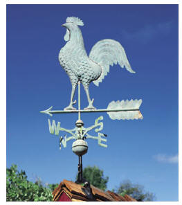
Big Idea:
We can use weather patterns to
predict future forecasts.
(Wind Speed)
Determine wind speed and direction by building and testing a
weather vane. (2.E.2.c) |
Wind
Read about wind basics including the
daily wind cycle, electricity generation from the wind, wind turbines, and
the history of wind power.
Renewable Energy - Wind
Power
Complete these activites based on the above article.
5
Day View of Wind Stream:
Students will follow the
path of the wind over a 5 day period
generated by the Fleet Numerical Meteorology
and Oceanography Center (FNMOC) on January 17, 2001. The colors on this
map indicate the speed of the wind, which is measured in knots. One knot
equals 1.1 mph. The red flags indicate wind direction.
Using Instruments to to Predict the Weather
(01:02)
Students will learn how meteorologists
use anemometers and wind vanes to measure wind speeds and wind direction.
This video segment demonstrates how to make a wind vane.
If the link does not work, login to Discovery Education first and then
select the link.
|
Big Idea:
We can use weather patterns to predict future forecasts.
(Precipitation)
Compare average daily
precipitation of two different cities during different seasons by creating
a Thinking Map. (2.E.2.d) |
NWS Website
(updated link, specifically for precipitation)
National Weather Service Data
- Advanced Hydrolic Prediction Service - Precipitation Map
Use this Thinking Map
to compare average daily precipitation of two different cities during
different seasons.
A Dire
Shortage of Water
Read World Reading: Parts of the southwestern United
States are in the middle of the worst drought in at least 500 years.
Focus Question: What are the long term effects of a drought on a
region?
Real World
Reading: In order solve the problem of CA droughts, scientists
are creating their own clouds to cause precipitation!!! A 2016 article
about Cloud
Seeding. Log into NewsELA to access this article.
DE
Board - Droughts
Learn more about droughts in the US, why they happen, and other long term
effects of droughts.
Watch each video and respond to each question(s) in Office 365/OneDrive or
Google Drive.
If the link does not work, login to Discovery Education first and then
select the link.
Higher
Temperatures to Come?
Scientists have been collected data for decades! See what trends they are
predicting for the future.
Log into NewsELA to access this article.
What
Will The Weather Be?
Engage Read the book
"Come On, Rain!" by
Karen Hesse, then complete
this activity to explore precipitation
Explain Respond to the story "What
Will the Weather Be?' by completing the reflection activity. Share with
your teacher as directed by using OneDrive/Office 365 or Google Drive.
Word
Google Doc |
|
|
Required
Lab:
Blown Away!
Student
Outcome:
Conduct an investigation about wind speed and direction in order to
compare average daily wind speeds and directions during different
seasonal data.
Predict severe storms for next year by analyzing the trends, the wind
speeds, and the wind directions from collected data. |
Build
an Anemometer to Measure Wind Speed ENGAGE
Students will follow directions to build an Anemometer to measure wind
speed. Using the tool, students will collect, record, compare, and analyze
the data.
Average
Wind Speed Over Time
(Data Chart) EXTEND
Compare
average wind speeds and directions for Portland, Oregon at different times
of the year using a data chart.
National
Wind Speed Map
Real-time
Wind and Weather Charts for Maryland
A great place to get real-time wind and weather charts for Maryland.
Four Choice
Processing Reflection EVALUATE
Wind Speeds - Compare the wind speed and direction in Portland to the wind
speed and direction currently at BWI Airport.
|
|
|
Project:
Emergency Preparedness Brochure
Driving
Question:
How can analyzing weather data help in daily and long-range planning?
Analyzing weather data to help in daily and long-range planning by
creating a severe weather brochure.
For classes attending Arlington Echo during the 3rd quarter, do
the project "Concerning
Climate" instead of the Emergency Preparedness Brochure. |
For Research - Beginning of Project
Weather Records
- Search by date, type or state OR
use this site for Storm
Events - search by state, county, etc.
NOAA
provides
Weather Safety Information.
Students will for information about major a major weather event.
Large
Scale Disasters in Each State
Students will read about different major weather events or large-scale
disasters in that area. Student will read to find out what types of
emergencies you may be at risk for, and get information on helpful
resources closer to home.
Disaster Master
Help the Heroes! Will you know what to do? Make the right decisions
of what to do in a disaster and earn points to unlock new levels. But
watch out! The wrong choice could end the game.
Zunal Weather WebQuest
(Can be Used for your research for brochure)
Weather is a constant in our daily lives. Sometimes severe weather can
affect our daily lives as well. Students, as a meteorologist will choose a
storm to research. Students will research past storms related to the storm
you are researching, the effects it has on the area, and how we as
citizens can prepare for these storms.
During Project
FEMA
Students will read about a major weather event and collect facts, data,
and images related to this weather event. Use a Thinking Map to
organize your facts.
Focus: Review research data to determine the likelihood of this type
of weather event occuring in your area.
Brochure Resources
Printing Press - Brochure - from ReadWriteThink
Brochure Template- PowerPoint
Brochure Template- Google Slides
|
|
Teacher Resources |
Curriculum
Links:
Readings, SMART board Lessons and Websites |
Resources |
Big
Idea:
We can use weather patterns to predict future
forecasts. |
World
Weather Compare: Comparing Average Precipitation/Temperature
Students will compare the daily temperature and precipitation of two
to three different areas.
The
National Weather Service Forecast Office
(revised link)
Once at the site, click on
Baltimore to get data about the city and a
close-up map of the region. Go back to the original map and click on
Cumberland for information about a mountainous region. At the main site,
manipulate the map using the arrow keys to locate
Ocean City. Using a
Thinking Map or Kidspiration, compare the current conditions of these
different cities. Or use
this Pixie to
compare and contrast these 3 locations in Maryland!
 Careers
in Science Careers
in Science
Weather Kids -Students will read
about what a meteorologist does for a living.
Why Are
Weather Symbols Used?
Read World Reading:
Short reading explaining weather symbols and their usage.
Focus Question: How do scientists use symbols to
communicate their findings and predictions.
Using Instruments to to Predict the Weather
(01:02)
Meteorologists use anemometers and wind vanes to measure wind speeds
and wind direction. This video segment demonstrates how to make a wind
vane.
If the link does not work, login to Discovery Education first and then
select the link.
 Using
Instruments to Predict the Weather Using
Instruments to Predict the Weather
Weather forecasting helps us to know what to expect and
help to keep us safe. Meteorologists use a variety of instruments to
forecast the weather.
If the link does not work, login to Discovery Education first and then
select the link.
Wind
Read about wind basics including the
daily wind cycle, electricity generation from the wind, wind turbines, and
the history of wind power.
A Dire
Shortage of Water
Read World Reading: Parts of the southwestern United
States are in the middle of the worst drought in at least 500 years.
Focus Question: What are the long term effects of a drought on
a region?
Updated Links:
NOAA Education Resources
NOAA Weather
Resources NWS Owlie's Page
Students will use this resource for readings, photos and research related
to severe weather patterns.
Mini-Project:
Engage students in giving a weather forecast - lesson and
rubric found
here
|
Required
Lab:
Blown Away!
Student
Outcome:
Conduct an investigation about wind speed and direction in order to
compare average daily wind speeds and directions during different
seasonal data. |
Real-time
Wind and Weather Charts for Maryland
A great place to get real-time wind and weather charts for Maryland.
 Blown
Away! Blown
Away!
Use this Smartboard presentation to guide the Lab with students.
|
Project:
Emergency Preparedness Brochure
Driving
Question:
How can analyzing weather data help in daily and long-range planning? |
Weather Records - Search by date, type or state
OR use this site for
Storm Events - search by state, county, etc.
National Oceanic and
Atmospheric Administration - weather systems and patterns.
NOAA
provides
Weather Safety Information.
Students will for information about major a major weather event.
FEMA
Interactive Activities and Games
FEMA's
Preparedness Brochure
Emergency
Preparedness Brochure
Use this Smartboard presentation to introduce and guide students through
this project!
|
|
Teacher Notes |
| Standards |
Resources |
Weather Patterns
Content
Standard:
Describe
different seasonal
weather conditions by using
data collected from weather
instruments, models
or drawings. (2.E.2.a)
Technology Standard:
6.0 Students will use technology and develop
strategies to solve problems and make informed decisions. |
Weather Watch
Using a Thermometer
NOAA
Interactive
Weather
Activities
The
National Weather Service Forecast Office
Teacher Note: Once at the site, click on Baltimore to get data about the
city and a close-up map of the region.
Real
World Reading:
Why Are
Weather Symbols Used?
Short reading explaining weather symbols and their usage
Careers
in Science:
Research what a meteorologist does for a living.
Weather Kids |
Daily Temperatures
Content Standard:
Compare
average daily temperatures during different
seasons
by collecting and analyzing data.(2.E.2.b)
Technology Standard:
5.0 Use technology to locate, evaluate, gather and organize
information and data. |
Comparing Average
Temperatures USA today weather data
Cool
Weather Careers (PowerPoint)
Resources for weather related careers in slide show format
Using Instruments to to Predict the Weather
Please note that the video must be downloaded prior to viewing as per
AACPS guidelines
|
Wind Speed
Content Standard:
Determine wind speed and direction by building and testing a weather
vane.(2.E.2.c.)
Technology Standard:
5.0 Use technology to locate, evaluate,
gather and organize information and data
|
Real
World Reading:
Wind
Read about wind basics including
the daily wind cycle, electricity generation from the wind, wind
turbines, and the history of wind power.
5
Day View of Wind Stream: Follow the
path of the wind over a 5 day period.
Using
instruments to predict the weather
Weather forecasting helps us to know what to
expect and help to keep us safe. Meteorologists use a variety of
instruments to forecast the weather.
Login to Discovery Education before selecting the Link. Please note that the video must be downloaded prior
to viewing as per AACPS guidelines.
BrainPop
Video: Explains where wind comes from,
what it is, the effect of local geography on wind patterns, and how
Earth’s rotation affects wind currents.
|
|
Required Lab: Blown Away!
Content Standard:
Predict severe storms for next
year by analyzing the trends, the wind speeds, and the wind directions
from collected data.
Technology Standard:
5.0 Use technology to locate, evaluate,
gather and organize information and data
|
Average
Wind Speed Over Time
Compare
average wind speeds and directions for Portland, Oregon at different
times of the year.
Build
an anemometer to measure wind speed.
|
|
Precipitation
Content Standard: Compare average daily
precipitation
of two different cities during different
seasons
by creating a Thinking Map.(2.E.2.d)
Technology Standard:
5.0 Use technology to locate, evaluate,
gather and organize information and data
|
NWS website:
National Weather Service Data
USA
Today Weather Teacher Note: Once at
the site, click on “Monthly Averages.”
Real
World Reading:
A Dire Shortage of Water
|
|
Project: Emergency
Preparedness Brochure
Content Standard: Analyze weather data to help in daily
and long-range planning by creating a severe weather brochure.
Technology Standard:
5.0 Use technology to locate, evaluate,
gather and organize information and data
|
FEMA
describes different types of natural disasters and suggestions on how to
be prepared.
National
Oceanic and Atmospheric Administration
provides
weather safety
information.
|